Thursday 28 April 2011

>>mAgMatiC eRuPtiOns

Strombolian

Diagram of a Strombolian eruption. (key: 1. Ash plume 2. Lapilli 3. Volcanic ash rain 4. Lava fountain 5. Volcanic bomb 6. Lava flow 7. Layers of lava and ash 8. Stratum 9. Dike 10. Magma conduit 11. Magma chamber

Strombolian eruptions are a type of volcanic eruption, named after the volcano Stromboli, which has been erupting continuously for centuries. Strombolian eruptions are driven by the bursting of gas bubbles within the magma. These gas bubbles within the magma accumulate and coalesce into large bubbles, called gas slugs. These grow large enough to rise through the lava column. Upon reaching the surface, the difference in air pressure causes the bubble to burst with a loud pop, throwing magma in the air in a way similar to a soap bubble. Because of the high gas pressures associated with the lavas, continued activity is generally in the form of episodic explosive eruptions accompanied by the distinctive loud blasts. During eruptions, these blasts occur as often as every few minutes.
The term "Strombolian" has been used indiscriminately to describe a wide variety of volcanic eruptions, varying from small volcanic blasts to large eruptive columns. In reality, true Strombolian eruptions are characterized by short-lived and explosive eruptions of lavas with intermediate viscosity, often ejected high into the air. Columns can measure hundreds of meters in height. The lavas formed by Strombolian eruptions are a form of relatively viscous basaltic lava, and its end product is mostly scoria. The relative passivity of Strombolian eruptions, and its non-damaging nature to its source vent allow Strombolian eruptions to continue unabated for thousands of years, and also makes it one of the least dangerous eruptive types.


An example of the lava arcs formed during Strombolian activity. This image is of Stromboli itself.
Strombolian eruptions eject volcanic bombs and lapilli fragments that travel in parabolic paths before landing around their source vent. The steady accumulation of small fragments builds cinder cones composed completely of basaltic pyroclasts. This form of accumulation tends to result in well-ordered rings of tephra.
Strombolian eruptions are similar to Hawaiian eruptions, but there are differences. Strombolian eruptions are noisier, produce no sustained eruptive columns, do not produce some volcanic products associated with Hawaiian volcanism (specifically Pele's tears and Pele's hair), and produce fewer molten lava flows (although the eruptive material does tend to form small rivulets).

Volcanoes known to have Strombolian activity include:
  • Parícutin, Mexico, which erupted from a fissure in a cornfield in 1943. Two years into its life, pyroclastic activity began to wane, and the outpouring of lava from its base became its primary mode of activity. Eruptions ceased in 1952, and the final height was 424 m (1,391 ft). This was the first time that scientists are able to observe the complete life cycle of a volcano.
  • Mount Etna, Italy, which has displayed Strombolian activity in recent eruptions, for example in 1981, 1999, 2002-2003, and 2009.
  • Mount Erebus in Antarctica, the southernmost active volcano in the world, having been observed erupting since 1972. Eruptive activity at Erebrus consists of frequent Strombolian activity.
  • Stromboli itself. The namesake of the mild explosive activity that it possesses has been active throughout historical time; essentially continuous Strombolian eruptions, occasionally accompanied by lava flows, have been recorded at Stromboli for more than a millennium.

Vulcanian

Diagram of a Vulcanian eruption. (key: 1. Ash plume 2. Lapilli 3. Lava fountain 4. Volcanic ash rain 5. Volcanic bomb 6. Lava flow 7. Layers of lava and ash 8. Stratum 9. Sill 10. Magma conduit 11. Magma chamber 12. Dike)

Vulcanian eruptions are a type of volcanic eruption, named after the volcano Vulcano, which also gives its name to the word Volcano.[17] It was named so following Giuseppe Mercalli's observations of its 1888-1890 eruptions.[18] In Vulcanian eruptions, highly viscous magma within the volcano make it difficult for vesiculate gases to escape. Similar to Strombolian eruptions, this leads to the buildup of high gas pressure, eventually popping the cap holding the magma down and resulting in an explosive eruption. However, unlike Strombolian eruptions, ejected lava fragments are not aerodynamical; this is due to the higher viscosity of Vulcanian magma and the greater incorporation of crystalline material broken off from the former cap. They are also more explosive than their Strombolian counterparts, with eruptive columns often reaching between 5 and 10 km (3 and 6 mi) high. Lastly, Vulcanian deposits are andesitic to dacitic rather than basaltic.[17]
Initial Vulcanian activity is characterized by a series of short-lived explosions, lasting a few minutes to a few hours and typified by the ejection of volcanic bombs and blocks. These eruptions wear down the lava dome holding the magma down, and it disintegrates, leading to much more quiet and continuous eruptions. Thus an early sign of future Vulcanian activity is lava dome growth, and its collapse generates an outpouring of pyroclastic material down the volcano's slope.[17]


Tavurvur in Papua New Guinea erupting

Deposits near the source vent consist of large volcanic blocks and bombs, with so-called "bread-crust bombs" being especially common. These deeply cracked volcanic chunks form when the exterior of ejected lava cools quickly into a glassy or fine-grained shell, but the inside continues to cool and vesiculate. The center of the fragment expands, cracking the exterior. However the bulk of Vulcanian deposits are fine grained ash. The ash is only moderately dispersed, and its abundance indicates a high degree of fragmentation, the result of high gas contents within the magma. In some cases these have been found to be the result of interaction with meteoric water, suggesting that Vulcanian eruptions are partially hydrovolcanic.[17]


Plinian

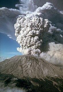
Diagram of a Plinian eruption. (key: 1. Ash plume 2. Magma conduit 3. Volcanic ash rain 4. Layers of lava and ash 5. Stratum 6. Magma chamber)

Plinian eruptions (or Vesuvian) are a type of volcanic eruption, named for the historical AD 79 eruption of Mount Vesuvius that buried the Roman towns of Pompeii and Herculaneum, and specifically for its chronicler Pliny the Younger. The process powering Plinian eruptions starts in the magma chamber, where dissolved volatile gases are stored in the magma. The gases vesiculate and accumulate as they rise through the magma conduit. These bubbles agglutinate and once they reach a certain size (about 75% of the total volume of the magma conduit) they explode. The narrow confines of the conduit force the gases and associated magma up, forming an eruptive column. Eruption velocity is controlled by the gas contents of the column, and low-strength surface rocks commonly crack under the pressure of the eruption, forming a flared outgoing structure that pushes the gases even faster.
These massive eruptive columns are the distinctive feature of a Plinian eruption, and reach up 2 to 45 km (1 to 28 mi) into the atmosphere. The densest part of the plume, directly above the volcano, is driven internally by gas expansion. As it reaches higher into the air the plume expands and becomes less dense, convection and thermal expansion of volcanic ash drive it even further up into the stratosphere. At the top of the plume, powerful prevailing winds drive the plume in a direction away from the volcano.


21 April 1990 eruptive column from Redoubt Volcano, as viewed to the west from the Kenai Peninsula.

These highly explosive eruptions are associated with volatile-rich dacitic to rhyolitic lavas, and occur most typically at stratovolcanoes. Eruptions can last anywhere from hours to days, with longer eruptions being associated with more felsic volcanoes. Although they are associated with felsic magma, Plinian eruptions can just as well occur at basaltic volcanoes, given that the magma chamber differentiate and has a structure rich in silicon dioxide.
Plinian eruptions are similar to both Vulcanian and Strombolian eruptions, except that rather than creating discrete explosive events, Plinian eruptions form sustained eruptive columns. They are also similar to Hawaiian lava fountains in that both eruptive types produce sustained eruption columns maintained by the growth of bubbles that move up at about the same speed as the magma surrounding them.
Regions affected by Plinian eruptions are subjected to heavy pumice airfall affecting an area 0.5 to 50 km3 (0 to 12 cu mi) in size. The material in the ash plume eventually finds its way back to the ground, covering the landscape in a thick layer of many cubic kilometers of ash.
However the most dangerous eruptive feature are the pyroclastic flows generated by material collapse, which move down the side of the mountain at extreme speeds of up to 700 km (435 mi) per hour and with the ability to extend the reach of the eruption hundreds of kilometers. The ejection of hot material from the volcano's summit melts snowbanks and ice deposits on the volcano, which mixes with tephra to form lahars, fast moving mudslides with the consistency of wet concrete that move at the speed of a river rapid.


Lahar flows from the 1985 eruption of Nevado del Ruiz, which literally wiped out the town of Armero in Colombia


Major Plinian eruptive events include:
  • The historical AD 79 eruption of Mount Vesuvius buried the Roman towns of Pompeii and Herculaneum under a layer of ash and tephra. It is the model Plinian eruption. Mount Vesuvius has erupted multiple times since then, for example in 1822.
  • The 1980 eruption of Mount St. Helens in Washington, which ripped apart the volcano's summit, was a Plinian eruption of Volcanic Explosivity Index (VEI) 5.
  • The strongest types of erupions, with a VEI of 8, are so-called "Ulta-Plinian" eruptions, such as the most recent one at Lake Toba 74 thousand years ago, which put out 2800 times the material erupted by Mount St. Helens in 1980.
  • Hekla in Iceland, an example of basaltic Pilian volcanism being its 1947-48 eruption. The past 800 years have been a pattern of violent initial eruptions of pumice followed by prolonged extrusion of basaltic lava from the lower part of the volcano.
  • Pinatubo in the Philippines on 15 June 1991, which produced 5 km3 (1 cu mi) of dacitic magma, a 40 km (25 mi) high eruption column, and released 17 megatons of sulfur dioxide.

>>mAgMatiC eRuPtiOns

Hawaiian
Diagram of a Hawaiian eruption. (key: 1. Ash plume 2. Lava fountain 3. Crater 4. Lava lake 5. Fumaroles 6. Lava flow 7. Layers of lava and ash 8. Stratum 9. Sill 10. Magma conduit 11. Magma chamber 12. Dike)

Magmatic eruptions produce juvenile clasts during explosive decompression from gas release. They range in intensity from the relatively small lava fountains on Hawaii to catastrophic Ultra Plinian eruption columns more than 30 km (19 mi) high, bigger than the AD 79 eruption that buried Pompeii.
Hawaiian eruptions are a type of volcanic eruption, named after the Hawaiian volcanoes with which this eruptive type is hallmark. Hawaiian eruptions are the calmest types of volcanic events, characterized by the effusive eruption eruption of very fluid basalt-type lavas with low gaseous content. The volume of ejected material from Hawaiian eruptions is less than half of that found in other eruptive types. Steady production of small amounts of lava builds up the large, broad form of a shield volcano. Eruptions are not centralized at the main summit as with other volcanic types, and often occur at vents around the summit and from fissure vents radiating out of the center.
Hawaiian eruptions often begin as a line of vent eruptions along a fissure vent, a so-called "curtain of fire." These die down as the lava beings to concentrate at a few of the vents. Central-vent eruptions, meanwhile, often take the form of large lava fountains (both continuous and sporadic), which can reach heights of hundreds of meters or more. The particles from lava fountains usually cool in the air before hitting the ground, resulting in the accumulation of cindery scoria fragments; however, when the air is especially thick with clasts, they cannot cool off fast enough due to the surrounding heat, and hit the ground still hot, the accumulation of which forms splatter cones. If eruptive rates are high enough, they may even form splatter-fed lava flows. Hawaiian eruptions are often extremely long lived; Pu'u O'o, a cinder cone of Kilauea, has been erupting continuously since 1983. Another Hawaiian volcanic feature is the formation of active lava lakes, self-maintaining pools of raw lava with a thin crust of semi-cooled rock; there are currently only 5 such lakes in the world, and the one at Kīlauea's Kupaianaha vent is one of them.

Ropey pahoehoe lava from Kilauea, Hawaiʻi.
Flows from Hawaiian eruptions are basaltic, and can be divided into two types by their structural characteristics. Pahoehoe lava is a relatively smooth lava flow that can be billowy or ropey. They can move as one sheet, by the advancement of "toes," or as a snaking lava column. A'a lava flows are denser and more viscous then pahoehoe, but tend to move slower. Flows can measure 2 to 20 m (7 to 66 ft) thick. A'a flows are so thick that the outside layers cools into a rubble-like mass, insulating the still-hot interior and preventing it from cooling. A'a lava moves in a peculiar way—the front of the flow steepens due to pressure from behind until it breaks off, after which the general mass behind it moves forward. Pahoehoe lava can sometimes become A'a lava due to increasing viscosity or increasing rate of shear, but A'a lava never turns into pahoehoe flow.
Hawaiian eruptions are responsible for several unique volcanological objects. Small volcanic particles are carried and formed by the wind, chilling quickly into teardrop-shaped glassy fragments known as Pele's tears (after Pele, the Hawaiian volcano deity). During especially high winds these chunks may even take the form of long drawn out rods, known as Pele's hair. Sometimes basant aerates into reticulite, the lowest density rock type on earth.
Although Hawaiian eruptions are named after the volcanoes of Hawaii, they are not necessarily restricted to them; the largest lava fountain ever recorded formed on the island of Izu Ōshima (on Mount Mihara) in 1986, a 1,600 m (5,249 ft) gusher that was more than twice as high as the mountain itself (which stands at 764 m (2,507 ft)).

>>eRuPtiOnS mEcHaniSms


Diagram showing the scale of VEI correlation with total ejecta volume

Volcanic eruptions arise through three main mechanisms:
  • Gas release under decompression causing magmatic eruptions.
  • Thermal contraction from chilling on contact with water causing phreatomagmatic eruptions.
  • Ejection of entrained particles during steam eruptions causing phreatic eruptions.
There are two types of eruptions in terms of activity, explosive eruptions and effusive eruptions. Explosive eruptions are characterized by gas-driven explosions that propels magma and tephra.Effusive eruptions, meanwhile, are characterized by the outpouring of lava without significant explosive eruption.
Volcanic eruptions vary widely in strength. On the one extreme there are effusive Hawaiian eruptions, which are characterized by lava fountains and fluid lava flows, which are typically not very dangerous. On the other extreme, Plinian eruptions are large, violent, and highly dangerous explosive events. Volcanoes are not bound to one eruptive style, and frequently display many different types, both passive and explosive, even the span of a single eruptive cycle. Volcanoes do not always erupt vertically from a single crater near their peak, either. Some volcanoes exhibit lateral and fissure eruptions. Notably, many Hawaiian eruptions start from rift zones, and some of the strongest Surtseyan eruptions develop along fracture zones.


Wednesday 27 April 2011

LetUsAn GuNung mErApi (VoLcAniC eRupTioNs)


The eruption of Mount St. Helens Volcano (USA), July 22, 1980
During a volcanic eruption, lava, tephra (ash, lapilli, volcanic bombs and blocks), and various gases are expelled from a volcanic vent or fissure. Several types of volcanic eruptions have been distinguished by volcanologists. These are often named after famous volcanoes where that type of behavior has been observed. Some volcanoes may exhibit only one characteristic type of eruption during a period of activity, while others may display an entire sequence of types all in one eruptive series.

 
Mosaic of some eruptive structures formed during volcanic activity: An eruption column from a Plinian eruption, Pahoehoe lava flow from a Hawaiian eruption, and a lava arc from a Strombolian eruption.

There are three different metatypes of eruptions. The most well-observed are magmatic eruptions, which involve the decompression of gas within magma that propels it forward. Phreatomagmatic eruptions are another type of volcanic eruption, driven by the compression of gas within magma, the direct opposite of the process powering magmatic activity. The last eruptive metatype is the Phreatic eruption, which is driven by the superheating of steam via contact with magma; these eruptive types often exhibit no magmatic release, instead causing the granulation of existing rock.
Within these wide-defining eruptive types are several subtypes. The weakest are Hawaiian and submarine, then Strombolian, followed by Vulcanian and Surtseyan. The stronger eruptive types are Pelean eruptions, followed by Plinian eruptions; the strongest eruptions are called "Ultra Plinian." Subglacial and Phreatic eruptions are defined by their eruptive mechanism, and vary in strength. An important measure of erruptive strength is Volcanic Explosivity Index (VEI), a magnitudic scale ranging from 0 to 8 that often correlates to eruptive types.


>>tHe pLaCe aT riSk


An evacuation route sign in case of volcanic eruption or lahar.

Several mountains in the world, including Mount Rainier in the US, Mount Ruapehu in New Zealand, and Galunggung in Indonesia, are considered particularly dangerous due to the risk of lahars. Several towns in the Puyallup River valley in Washington state, including Orting, are built on top of lahar deposits that are only about 500 years old. Lahars are predicted to flow through the valley every 500-1,000 years, so Orting, Sumner, Puyallup, Fife, and the Port of Tacoma face considerable risk. The USGS has set up lahar warning sirens in Pierce County, so that people can flee an approaching debris flow.
A lahar warning system has been set up at Mount Ruapehu by the New Zealand Department of Conservation and hailed as a success after it successfully alerted officials to an impending lahar on 18 March 2007.Preventative measures by the Philippine government did not stop over 20 feet (6.1 m) of mud from flooding many villages around Mount Pinatubo from 1992 through 1998.


Nevado del Ruiz
The lahar from the 1985 eruption of Nevado del Ruiz that wiped out the town of Armero in Colombia.

In 1985, the volcano Nevado del Ruiz erupted. As pyroclastic flows erupted from the volcano's crater, they melted the mountain's glaciers, sending four enormous lahars down its slopes at 60 kilometers per hour (40 miles per hour). The lahars picked up speed in gullies and coursed into the six major rivers at the base of the volcano; they engulfed the town of Armero, killing more than 20,000 of its almost 29,000 inhabitants. Casualties in other towns, particularly Chinchiná, brought the overall death toll to 23,000. Footage and photographs of Omayra Sánchez, a young victim of the tragedy, were published around the world. Other photographs of the lahars and the impact of the disaster captured attention worldwide and led to controversy over the degree to which the Colombian government was responsible for the disaster. A banner at a mass funeral in Ibague read, "The volcano didn't kill 22,000 people. The government killed them."


 Mount Pinatubo
Before and after photographs of a river valley filled in by lahars from Mount Pinatubo

The 1991 eruption of Mount Pinatubo caused lahar flows: the first eruption itself killed only six people, but the lahar flows killed more than 1500. The eye of Typhoon Yunya passed over the volcano during its eruption on June 15, 1991. The rain from the typhoon triggered the flow of volcanic ash, boulders, and water down the rivers surrounding the volcano. Angeles City was damaged by the volcano's sticky mud when Sapang Balen Creek and the Abacan River became the channel for the lahar and carried it to the heart of the city. Over 20 feet (6 m) of mud destroyed or damaged Castillejos, San Marcelino, Botolan, Porac, Mabalacat, Tarlac City, Capas, Concepcion, and Bamban. The mud flow down the Sacobia Bamban River scoured all structures in its path, including the bridges and dikes by the Parua river in Concepcion. The Tarlac River in Tarlac City was inundated by over 20 feet (6 m) of lahar, causing the river to lose the ability to hold water.
On the morning of October 1, 1995, pyroclastic material which clung to the slopes of Pinatubo and surrounding mountains rushed down because of heavy rain, and turned into a 25-foot (8 m) lahar. The mudflow killed hundreds of people in Barangay Cabalantian in Bacolor. The Philippine government under former president Fidel V. Ramos ordered the construction of the FVR Mega Dike in an attempt to protect people from further mudflows.


>>tHe cAuSes oF LaHar


This mudline left behind on the trees on the banks of the Muddy River after the 1980 eruption of Mount St. Helens shows how high the lahars reached here.

Lahars have several possible causes:
  • Snow and glaciers can be melted by lava or a pyroclastic flow during an eruption
  • A flood caused by a glacier, lake breakout, or heavy rainfall can release a lahar, also called glacier run or jökulhlaup
  • Water from a crater lake, combined with volcanic material in an eruption
In particular, although lahars are typically associated with the effects of volcanic activity, lahars can occur even without any current volcanic activity, as long as the conditions are right to cause the collapse and movement of mud originating from existing volcanic ash deposits.
  • Earthquakes underneath or close to the volcano can shake material loose and cause it to collapse triggering a lahar avalanche.
  • Rainfall or typhoons can cause the still-hanging slabs of solidified mud to come rushing down the slopes at a speed of more than 30 Kilometers per hour, causing devastating results.

Tuesday 26 April 2011

LaHar


A lahar from the 1982 eruption of Galunggung

A lahar is a type of mudflow or debris flow composed of pyroclastic material, rocky debris, and water. The material flows down from a volcano, typically along a river valley. The term is a shortened version of "berlahar" which originated in the Javanese language of Indonesia.

"Lahar" is an Indonesian word that describes volcanic mudflows or debris flows. Lahars have the consistency, viscosity and approximately the same density of concrete: fluid when moving, then solid when stopped. Lahars can be huge: the Osceola lahar produced 5,600 years ago by Mount Rainier in Washington produced a wall of mud 140 metres (460 ft) deep in the White River canyon and covered an area of over 330 square kilometres (130 sq mi) for a total volume of 2.3 cubic kilometres (0.55 cu mi). A lahar can bulldoze through virtually any structure in its path, but quickly loses force when it leaves the channel of its flow: even frail huts may remain standing while being buried up to the roof with mud. The viscosity of a lahar decreases with time and amount of rain, although the mud solidifies quickly when it stops moving

Lahar flows are deadly because of their energy and speed. Large lahar flows move at approximately 100 kilometres per hour (60 mph), can flow for more than 300 kilometres (190 mi), and can cause catastrophic destruction in their path. The lahars from the Nevado del Ruiz eruption in Colombia in 1985 caused the Armero tragedy, which killed an estimated 23,000 when the city of Armero was buried under 5 metres (16 ft) of mud and debris. New Zealand's Tangiwai disaster in 1953, where 151 people died after a Christmas Eve express train fell into the Whangaehu River, was caused by a lahar. Lahars have been responsible for 17% of volcano-related deaths between 1783 and 1997. Lahars can cause fatalities years after an actual eruption: for example, the Cabalantian tragedy four years after the 1991 eruption of Mount Pinatubo.